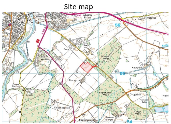
Land at Blackpark Farm, Nairn
Technical & Contextual Considerations
A range of technical assessments are in the process of being undertaken to allow our team to understand, and respond positively, to the opportunities and constraints of the site. These reports will be available when the formal planning application is submitted, however initial baseline work suggests that there are no significant constraints to development that cannot be appropriately mitigated.
The key considerations in developing the layout and proposals for the site are outlined below:
Access
• Access to the site will be via the existing private access road off Granny Barbours Road. The A96 lies c.1km to the north of the site, providing access to the trunk road network.
• A new private access will be formed off this private access road, for construction and maintenance vehicles to access the site.
• The layout of the site has been designed so that construction vehicles can park and turn around within the site.
• Once in operation the battery storage facility will be accessed by two maintenance vehicles a month, an imperceptible increase on the local highway network.
Trees, Landscape & Open Space
• The site forms part of a larger agricultural field immediately adjacent to urban fringe industrial uses on the edge of Nairn, with Grigorhall Industrial Estate lying c.60m to the north of the site. A Substation is also located within the Industrial Estate, and the wider landscape is characterised by High Voltage Overhead Pylons.
• A Landscape & Visual Appraisal will accompany the planning application, considering the impact of the proposed development on the surrounding landscape and visual receptors.
• There are no landscape or heritage designations identified within or directly adjacent to the site.
• There is potential for landscape mitigation measures to screen the proposed development and make it less noticeable in views. A Landscape Plan will accompany any future planning application.
Topography
• The topography of the site broadly slopes down from c.25m Above Ordnance Datum (‘AOD’) along the south east boundary, down to c.20m AOD along the north western boundary.
• A topographical survey will be conducted to inform the final design of the proposed development.
Flooding & Drainage
• The site does not appear to be at any risk of river or coastal flooding as denoted by SEPA’s online Indicative Flood Maps. Small parts of the site appear to be at medium to high risk of surface water flooding.
• The proposed development will be accompanied by a Flood Risk Assessment, giving further consideration to potential sources of flooding within the site. The proposed development will respond to any identified areas of flood risk as applicable.
• A SuDS-compliant drainage design is being progressed to reduce the potential flood risk posed by the proposed development.
Ecology
• A Preliminary Ecological Appraisal is being undertaken to assess any potential impact the development may have on local habitats and protected species.
• Should the Preliminary Ecological Appraisal identify the need for further surveys regarding any important species, these will be conducted in the optimum survey season relative to each species to assess the impact of the proposed development and establish suitable mitigation measures if appropriate.
Noise
• Consultation will be conducted with the Highland Council to agree assessment methodology and criteria. Criteria will be agreed in line with policy and best practice to avoid adverse impact of noise.
• Unattended background sound measurements will be conducted at the agreed location and a noise modelling exercise will follow to predict the noise impact.
• A Noise Impact Assessment (‘NIA’) will accompany the planning application, and within this NIA, appropriate mitigation measures will be identified, where necessary, to avoid any adverse impact to any noise sensitive land uses in the surrounding area.
FEEDBACK
Anesco encourages views from residents on the proposal as laid on this webpage.
Closing date for feedback is 14th December 2022.


